Showing posts with label Buildings Moved or Salvaged. Show all posts

Friday, May 26, 2023

Bayocean Losses Tallied

At one time or another, the resort town of Bayocean included everything listed below, as chronicled in Bayocean: Atlantis of Oregon. Absolutely nothing remains. 

59 Residences (not all stood at the same time; the number peaked at 36 in 1939):
30 slid to the sea, undercut by erosion 
  8 were deconstructed 
  6 were moved off the spit before it became an island in 1952
  4 burned down for lack of a fire department
  9 were burned, and buried to enable construction of the breakwater  that reconnected the island to Cape Meares in 1956
  2 had unknown fates 
Rock crusher: used to manufacture 3.5 miles of concrete streets  and sidewalks along High Terrace and Twelfth Avenues                Two schoolhouses
Machine shop 
Warehouses: at least two; many untallied outbuildings 
Kaaran Ann Kottages: a duplex
Cottage Park42 rental cottages (the number and style varied) 
Annex: 38 guest rooms and a restaurant
Amusement Pavilion: a three-sided structure including a bowling alley, billiard room, ice cream parlor, game room, and curio shop
Tennis courts
Bayside Inn: 24 guest rooms and a restaurant 
Three dance halls: at different times, the last put up by Reed College students when they ran the resort in 1921
The Mitchella mercantile with at least three apartments upstairs
Pierone quarter mile long, with a harbor for ocean-going ships
Water lines: run from Coleman Creek on Cape Meares
Sewer lines: run along High Terrace and Twelfth Avenues 
6-7 million cubic yards of sand: which would have filled a cube 545’ to  573’ on each side, roughly two Portland city blocks and the street between

To find other articles of interest, see the Index or scroll through them on the Home page. 

Monday, November 21, 2022

Bayocean Homes and Their Fate

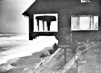
 The house last owned by Harry Roberts, photographed by the 
Corps of Engineers in February 1940, not long before it fell. 
After first hearing about Bayocean eight years ago, I set out to locate the  schoolhouse and six cabins  (counting the Pagodas as two) moved to the mainland before the south end of the spit was blown out by a storm surge in November 1952, a disaster from which the resort town never recovered. I had just located the last of them when Grant McComie called in June 2015 to ask for assistance regarding a program on Bayocean. I then thought it would be interesting to know where the buildings were located on the spit. That led to an obsession with finding every residence ever built on Bayocean, and to learning as much as I could about the homeowners who lost them.  It took me another seven and a half years to achieve that goal. 

If Bayocean Park had been platted in the 1970s, it would have been much easier to locate buildings because property owners would have been required to purchased permits and get an inspector's approval before occupying their homes, resulting in a detailed chronological record readily accessible at the Tillamook County Courthouse. But while the resort town of Bayocean existed, none of that was the case. Homebuilding was a kind of free-for-all. So, I was forced to look for names in newspaper articles, then search deed indexes at the county clerk's office, track ownership back and forth, and go back to look for the other names in newspapers.

Most large metropolitan newspapers like the Oregonian were digitized, so I was able to search them online, but that was true of very  few Tillamook County newspapers. So, I read every original edition or microfilmed copy looking for any mention of Bayocean. Information I was excited to find one day often conflicted with information found elsewhere later. Personal memoirs, government reports, and other archival records helped me parse it all out and fill in gaps. I ran into many dead ends along the way, but most of the remaining pieces of my self-induced Bayocean puzzle fell into place when Denise Vandercouvering, Tillamook County Assessor worked out a way for me to look through historical assessment rolls stored in the courthouse basement after I learned they were organized chronologically by subdivision - just what I needed. 

In Bayocean: Atlantis of Oregon, hopefully published in the next couple of months, I will tell the story of homeowners I was able to find, so readers can get a sense of what they experienced. And I mention at least the first and last owners of each of the fifty-nine houses built and lost on the spit. Some were magnificent, some were shacks or converted garages, but they were all considered home by someone. 

My tally does not include houses on the mainland - one of which was destroyed, others moved, some more than once - because my book is about the spit, which I consider everything north of South Gap (Shell Street and 2nd Avenue) because it was the southern limit of the November 1952 blowout. I counted the Pagodas as two houses because one was built later than the other on the spit, lived in by different individuals, and referred to as such by neighbors. Others might choose criteria that result in a different tally. 

To help myself and readers keep track of the fifty-nine residences, I built a spreadsheet listing each one, their demise, lot numbers, and the last names of each owner. Unfortunately, it was too large to include as an appendix in my book, but you can view and/or download it here. Locating each home will require you to view and/or download the Bayocean Park plat map, which I could not fit on two pages pages of my book and provide sufficient detail. 

For more stories about Bayocean and the challenges of researching it, check out the Index page. To reach a comprehensive narrative, read Bayocean: Atlantis of Oregon

Saturday, February 23, 2019

1949 Ackroyd Aerial Depicts Bayocean Hotel Ruins and Erosion

For years I wondered about the posts visible during low tide running parallel to Dike Road and wider posts just barely visible above the mudflats crossing the small inlet just northeast of the gate at the south end of the hills. 

I found no evidence of them in aerial photos and maps from individual and archival sources or Army Corps of Engineers records at the National Archives. I thought the posts might have been installed after the breakwater was built in 1956 because they were far out into the bay before then, though not to the end of the original pier. Perry Reeder said they were there when he was a kid. He thought they were what's left of bulkheads used to protect the bay side of the spit during storms. A recently discovered aerial photograph, taken by Hugh Ackroyd in 1949, confirms Perry's recollections. The view is from the southwest, so 12th Avenue, leading down to the pier is out of sight to the right. 

Print and high-resolution digital versions of Ackroyd 01751-05 can be ordered at www.historicphotoarchive.net or by calling
 Thomas Robinson at 503-460-0415. He was kind enough to allow me to display it here when I told him the significance.

Posts running parallel to Dike Rd and crossing the inlet from the gate at the base of the hills.


Comparing Ackroyd's 1949 aerial to a profile view from the north not long after the Bayocean was finished - 100' elevation - in 1912 gives you a sense of the great volume of sand lost to erosion during the intervening 37 years. The concrete walls and basement of the first floor of the Annex were all that remained after the upper stories were deconstructed, by 1938.

Bayocean photo #214 at the Tillamook County Pioneer Museum. Call (503) 842-4553 for print or digital copies.
The cottages shown at the top were all built by Johan Poulsen, Portland lumber baron, in 1912 for use by himself and his daughters' families. They were rented out to the Coast Guard to house a war dog beach patrol unit during World War II. The most southerly of the houses, known later as the Hicks House, was moved to the mainland in 1952, just before Bayocean became an island. The house closest to the edge was sold to A.T. Dolan.  It burned to the ground shortly after Ackroyd shot his aerial. The house closest to the bay, also last owned by the Hicks, fell to the shore in 1954. The last house to fall (Notdurft's; hidden behind the trees to the right) succumbed in 1960.   
See the Index page to find more stories like this.


Saturday, June 17, 2017

Sherwood House

Photo from Lorraine Eckhardt's Bayocean album. The first and middle names of Albert 
George and Orilla Sarah Jones are reversed in many official and unofficial records.  
A handwritten note from Howard Sherwood, Jr. (Buck) in the Cape Meares (Bayocean School) Community Center scrapbook says that George A. Jones salvaged lumber from the Bayocean Natatorium to build a large house for himself and his wife "Rilly" on Cape Meares in 1933 and 1934. He also installed a buggy above a tall hop plant out front, rented out a few rooms, kept a few grocery items to sell picnickers, and called their place the "Buggy Knot Inn." 

Photo of the south side of the house from Cape Meares Community Center
(Bayocean School) scrapbook. People unidentified. A buggy wheel is just
barely visible on the left, which would be in the front of the house. Columns
attributed to the Bayocean Natatorium are shown extending above the roof.
Photo of Buck Sherwood from Mike Watkins, taken six years
before his death in 2005. Buck took many photos of Bayocean 
used in newspaper articles, books and on websites, like mine.  


Testimony submitted to the US Army Corps of Engineers (USACE) by Jones in 1938* suggests another source of lumber for their home. He reported surveying and supervising early construction on Bayocean, from 1907 to 1909, and returning to the area in 1930. In 1932 he purchased and deconstructed the summer cabin of D.S. and Vesta Williams. In 1961, Samual Dicken, head of the Oregon State University Geology Department, wrote in a report titled "Some Recent Changes of the Oregon Coast" that the Williams cottage was on a bench in the dunes about 50' above the beach and that he measured erosion at 1' per year from 1926 (when it first became noticeable) until 1932 when it jumped to 6' per year. Tillamook County Deed Book 32, page 535 (DB 32:535) shows they purchased lot 22 in block 67 (67:22) in 1915. Judge George Bagley and Swan Hawkinson, who also had Bayocean cottages, confirmed Jones' account in their testimony to the USACE. Hawkinson said the Williamses first tried moving their house uphill and away from the ocean. Their cottage would have been much smaller than Jones' house so he needed more lumber. 

Buck Sherwood told Mike Watkins, his boyhood neighbor and lifelong friend, that Jones built the house for less than $1000. This figure would have included what Jones paid Williams and the Tillamook-Bayocean Company who then owned the Natatorium. Why didn't Jones mention Williams to Buck (his family didn't move to Bayocean until 1938, so all of what he wrote must have come from Jones)? Perhaps it just wasn't as good a story. If Jones had realized it, he could have bragged that some of his home's lumber came from the most northerly home ever built on a Bayocean lot. The Williams cottage was near the end of the paved section of High Street, a half-mile north of the first house lost five years earlier, and 1000' north of the Mueller cabin (see the map in that post to locate these properties) moved over to the bayside five years later.  

Jones had purchased the lot (12:15) in the Oceanview Subdivision from George Higgins back in 1915. While still serving as the Cape Meares Lighthouse Keeper, Higgins took advantage of Bayocean publicity by developing and advertising his lots in Tillamook newspapers (the Potters advertised in big city papers) as a lower priced alternative. Jones and his wife bought eight adjacent lots (7-12 and 16 -17) during the 1930s. Buck said his family moved into the house in 1940. The deed for Howard (Sr.) and Maude Sherwood's purchase of all nine lots was not recorded until 1948 (DB 116:269) so they likely bought them on contract. Members of the family continued living there until 1990, which is why neighbors still refer to it as the "Sherwood House."

See the Index page to find more stories like this. 

* From USACE records at the Seattle branch of the National Archives: POR-81; Civil Works Project Files, 1902-1968; Box 175; File 7250 Bayocean Preliminary Exams & Surveys.

Wednesday, June 7, 2017

Moving It Didn't Save Muellers' Cabin


 Lorraine Eckhart's Bayocean album includes this photo with notes added by Buck SherwoodThe Notdurft cottage at the top
 was the last house to fall. The "Rainbow House" in the middle was deconstructed by Lewis and Hilda BennettTheir garage 
was the last structure to go, in 1971.
When the US Army Corps of Engineers (USACE) built the breakwater that reconnected Bayocean spit to the mainland in 1956, they also bulldozed and burned all but three of the buildings still standing, and then backfilled the entire area with sand dredged from the bay to add elevation and avoid future breaches. The house in the photo with its basement filled with sand and labeled "Mueller place" had been moved there from the northern ridgeline a couple decades earlier - to escape erosion. 

According to Tillamook County Deed Book 67, pages 280-281 (DB 67:280-281), Conrad and Elvira Mueller purchased lot 52 in block 67 (67:52) on June 11, 1932. This was on the ocean side of High Street, about 3/8 of a mile north of the Poulsen (later Hicks/Dolan) houses, directly across from the first Bayocean house owned by Judge George Bagley, at lot 62:A (he also owned adjacent lots 13-16). 

Testimony submitted to the US Army Corps of Engineers in 1938 by Judge Bagley (POR-81; Civil Works Project Files, 1902-1968; Box 175; File 7250 Bayocean Preliminary Exams & Surveys. Seattle NARA) said that a newer house across the street from his had been moved down to the bay just the year before (1937) in order to avoid the threat of erosion. Bagley and others mention two other houses in the same block that were deconstructed instead of moved. The Muellers likely chose to move theirs because they had just built it (one can only imagine that the rate of erosion had suddenly increased). 

D.C. Baker built a basement and placed the house for the Muellers on a lot they purchased June 7, 1937, at 57:29 (DB 74:89). "Bayocean News" columns in the Tillamook Headlight Herald gave periodic updates during the summer and fall of 1937, talked about Baker having been an early manager of Cottage Park, and declared on October 7th that the house was "practically ready for occupancy again, after being moved from the hill to a location near the [Rainbow] Girl's Club building." They later purchased adjacent lots 30 and 31 at foreclosure sales. 
Section of original Bayocean plat map from Tillamook County Surveyor's office. Mueller locations are colored green,
as is the route their house would have taken. Bagley lots are in orange. Other landmarks are purple. 
The Muellers called their cabin on the bay "Huckleberry Inn" and traveled from their home in Portland to stay there frequently. A sketch on page 81 of Bayocean: The Oregon Town That Fell Into The Sea refers to Conrad as "Horse." This is interesting given his WW II draft card lists his height at just 5'5". Censuses and directories indicate Mueller was a building contractor, so perhaps great strength earned him the nickname (sources were viewed at Ancestry.com).  

On May 8, 1945 (DB 90:607-608) the Muellers sold their cabin. By the time Perry Reeder's family rented it in 1947 subsequent owners had hung a sign on the front porch renaming it the "Dew Drop Inn." Perry recalls the vine roses clinging to a fence that ran the perimeter of the property and made good use of the large chicken coop in the back. 

The last owners of the house were the Currins, who purchased it June 25, 1952 (DB 134:90-91), just five months before the entire southern part of Bayocean was blown out by a winter storm. This was the fourth house lost by the Currins on Bayocean. If they reasoned that "this would have to be one of the last houses to go" when they bought it they would have been right - but it did go. 

See the Index page
 for other posts listed by category. 

Friday, August 7, 2015

Locating Bayocean School

One of the buildings Bert and Margie Webber did not locate on their drawings in Bayocean: The Oregon Town that Fell Into the Sea was the Bayocean School. Written reports said it was close to Cape Meares, and Perry Reeder pointed to the area on the original Bayocean Park plat map where the narrow southern section of the spit started to widen out, but I wanted to find the exact location so I can stand there like I had the Bayocean Hotel

When I met Mike Watkins, he remembered that the school had been just a little northwest of the west end of Arthur Beals' dike. The dike had a one-way gate that let Coleman Creek flow out at low tide but kept Tillamook Bay water from coming back in at high tide. This changed the wetland into a meadow that dairy cows could graze. When he came to believe the ocean would eventually take the spit, Beals sold much of his Bayocean/Cape Meares holdings to Mike's grandfather, Robert W. (Pop) Watkins. The land at the east end of the dike passed down to Mike and his siblings, which is why he's so familiar with it. When the breakwater that is now Dike Road sealed the breach in 1957, the ocean beach reformed (east of its previous location) and created Cape Meares Lake. Though the meadow and dike are now submerged, Mike said that remnants of the dike were still visible and could be used to point to where the school had been. 


Corps of Engineers aerial photograph # 39-1546, cropped. 
Then I looked at 1939 aerial photographs from the Army Corps of Engineers. Because it was earthen, the dike is lighter in color and stands out against the grey background. By zooming in, I saw the schoolhouse just northwest (up and left in the photograph) of where the dike ends at the spit, confirming Mike's recollection. I also noticed that the school was in line with 4th Street, which is the road at the bottom of the photograph running south (down) from Bayocean (or Mears) Rd which runs east to west (left to right). Since 4th Street still exists, this gave me two sightlines, which were the same today as in the past, that I could use to find where the school had been on today's landscape. 

That would have been good enough, but while looking at the Tillamook County Tax Map for other reasons I noticed an active tax lot in the area. The Summary Report for lot #1200 shows it's owned by Tillamook County School District #9. Like many other landowners, they'd kept ownership over the years. ORMAP and other GIS mapping systems project county tax lot layers onto modern aerial landscape views and provide GPS coordinates where a cursor is placed. Coordinates at the center of the school lot are 45.505148 N, 123.958730 W. The school may not have been at the center of the lot, but since the tax lot is only 100' x100' (.23 acres) it couldn't have been far from it. Now I had two ways to locate the school. 

The next step was a field trip. Mike was gracious enough to lead me down a trail (viewing deer and an eagle along the way) to what had been the east end of Beals' dike. From there we were able to sight the west end using dike remnants. We then hiked out on the spit. Sighting south to 4th street, and east along the dike, we arrived at a spot on the beach where the coordinates matched. We were there! The spot is just 1/10 mile north of the parking space at the end of Bayocean Road, so easy to reach, and a stump just east of the spot makes it hard to miss. If the ocean reclaims or moves the stump, the coordinates will still work. Based on the aerial photograph and county tax map, the road out to Bayocean from Cape Meares would have been about 500' west of the spot. The average high tide in 1939 would have been about 1000' out. 

Left to right: James Bennett, Rosemarie Bennett, Barbara Parker,
Russell Parker; photo from Tillamook County Pioneer Museum
When I asked, Mike recalled the school grounds being about 10-15' above sea/bay level. After leaving Mike, I saw Harold Bennett in his yard. He had attended Bayocean School, so I stopped to let him know about the stump, and asked him what he thought the school elevation had been. His answer was the same as Mike's. I later found a 1939 USACE topo map confirming Mike's and Harold's recollection. When you stand there, listen for the yells of children at play in the wind above you. 

Wednesday, June 24, 2015

Three Other Houses Moved From Bayocean

Previous posts discussed moving the Bayocean schoolhouse, Hicks house, and  Pagoda House(s) to the mainland before the November 1952 breakthrough could destroy them. Three other houses were moved, though only two remain. 


Photo of A.G. Beals house on Bayocean, which Sherwoods rented. Courtesy of Mike Watkins.
Jerry Schlegel says that when A.G. Beals (a prominent Tillamook businessman) heard Woodrow Chase was moving some houses off the spit, he paid him $2,000 to move a house from just south of the Bayocean schoolhouse to a knoll about the meadow at the mouth of Coleman Creek. Barbara Bennett said Beals never lived in the house but rented it out. The people who owned the house in 1976 replaced it with another that looks very similar.

Photo by the author
This house was owned by O.P. Brigham. Pop and Bob Watkins bought it and moved it to a lot along Bayocean Road in November 1952. It was the last house moved. 

The house below was given to Jerry Schlegel in return for the work he did moving houses from Bayocean to Cape Meares for Chase. Jerry lived in Forest Grove at the time but his family used it as a beach house for several years. It still stands in Cape Meares.  It was originally built for Corinth Crook and sat near the Pagodas along the ridgeline. Woody Chase bought it from George and Merle Selfridge and moved it in the summer of 1949. 

Photo of Schlegel house while still on Bayocean, from Bayocean
school scrapbook in the Cape Meares Community Center 


Recent photo by the author of the house that was first owned by Jerry 
Schlegel after being moved to Cape Meares from Bayocean


Friday, June 5, 2015

The Hicks House


One building moved from Bayocean is referred to as the "House of Hicks" because it was last owned by C.G. Hicks. Located on the highest point of the town, at the apex of High Street, Bay Terrace, and 14th Avenue, it sat catty-corner to the Bayocean Hotel Annex. It's the one on the right, south of the other two, in the photo below.
 
This photo, from Tillamook County Pioneer Museum, must have been taken
from a hotel room on the northeast corner, looking northeast.
In What Happened At Bayocean: Is Salishan Next? Expanded Edition (12-13) Bert Webber reported that all three homes were built by Johan Poulsen, a prominent Portland lumberman, and continually owned by family members. In 1944, after having rented it to the US Coast Guard during World War II for a war dog beach patrol, they sold one to A.T. Dolan and one to C.G. Hicks. The third went through several owners until Hicks bought it near the end. The tenants Bayocean alumni recall are the McManns, primarily because their daughter Mickie was a tomboy who could hold her own in BB fights with the boys in the woods. Webber said these were the most extravagant homes on Bayocean. Perry Reeder said that a butler answered the door at the Hick's house. 

Barbara Bennett said that it was known as the "House of Hicks" because they operated a catering service there. Joann Steffey, the daughter of A.T. Dolan, said Hicks also owned a restaurant by that name in Portland. This is confirmed by the January 1947 newsletter of the Geological Society of the Oregon Country, which held a meeting there.

Early in 1952, Hicks accepted the inevitable and sold both houses at a salvage price to Lebeck and Sons Construction of Portland (Deed Record 134, pages 503-503), who then sold it to Mr. and Mrs. Charles Ross for $7,000, including the move (February 7, and March 27, 1952 articles in the Tillamook Headlight Herald ). They subcontracted Leonard Bales Construction and Morgan Burckard Plumbing to help them get the house ready to move. Leslie Bales was with her father the entire time, and later married Morgan's son Gus. She was only nine years old, but remembers being frightened by the cliff moving closer to the house each day. One of the photos depicts this clearly, in that the Hotel Bayocean Annex, which was to the right of the Hicks house, had already fallen 100' to the beach below. 
Looking north, from the south down route taken.
Dorian Studio photo provided by John Chaix
Photo taken from the north, looking south, ocean to the right, hotel 
ruins gone. The Dolan house is not obstructing the view because 
it had burned down.  Dorian Studio photo provided by John Chaix

In order to get it onto a barge and ship it across the bay, the house had to be cut in half. Dr. Rex Parsons, who lived in the house from 1983 to 2002 was told that Mrs. Ross (just 5' tall) ignored state policemen's orders to stop because of concerns that the house was too close to the power lines, and just "kept on trucking". He added a two-story addition that's not shown in the photo below, but he preserved the original walls and ceilings of two bedrooms, the bath between them, and the hallway leading to them because they were old-growth, tongue-and-groove, clear fir.

The Tillamook Headlight Herald reported on February 21, 1952, that the first Hick's house was moved a week earlier and that the crews intended to come back for the second house the following week, but they never did. In their March 27 issue, Lewis Bennett explained that by the time they could return the foundation of the second house was crumbling, so they packed up their equipment and headed back to Portland. Another likely factor was that (as reported in the paper) a breach made the road impassable from March 20 to April 3. On December 10, 1953 the paper shows the second Hicks house sitting alone with the garage of the first one. 

Monday, May 18, 2015

Pagoda House(s)

After the Bayocean School (now the Cape Meares Community Center), the Pagoda House is the most famous of the buildings moved from Bayocean to Cape Meares before a 1952 winter storm inflicted final destruction on the once-thriving resort town.

A recent photo by the author of the Pagoda House in Cape Meares (address withheld to protect the privacy of residents) 
They were two separate houses on Bayocean, on the east side of Clarke Street, joined by a hallway because the residents were close friends. One of them had been moved from a previous location on the west side as the dune approached. The photo below was taken at the original location, with the front door facing east, away from the force of winter storms. 
Photo from Oregon Historical Society photo collection 93-B.
Harold Bennett recalls his mother cleaning house for the Miss Cake and Miss Brownell, ladies who lived in the second Pagoda full time in the mid-1940s. Harold's brother James did yard work and split wood for them, according to his widow Barbara

Photo by Howard "Buck" Sherwood
of Pagoda Houses being prepared for the move
 from Cape Meares Community Center scrapbo

Photo by Buck Sherwood, courtesy of Mike Watkins,
 who lived in the Pagoda house(s) on Cape Meares


Milton and Jerry Schlegel (Barbara's father and brother), and Woodrow (Woody) Chase, a logger from Willamina, moved the Pagoda houses, and others, to the mainland as erosion threatened them at the new location. They used a tractor to push and pull the truck through bad spots like the gaps. The Tillamook Headlight Herald of April 7, 1949, announced the start of the process. 

During that summer, Milton and Jerry excavated property purchased on Pacific Avenue in Oceanside, built a basement, and fit the two houses together on top of it. On August 11 the Tillamook Headlight Herald described a larger housewarming by Bob and Barbara Watkins that celebrated its completion.  Mike Watkins was a young boy then, but he recalls a dumbwaiter that came with the house which his father wouldn't let them use to lift wood from the basement. His father had them remove the fancy rafter end trim because it was too fancy. As can be seen in the photos, the house originally had clapboard siding. Shingles were added before being moved and maintained for decades. More recent owners removed the shingles and went back to the original siding. Mike still owns a beach house next door. 
  

Wednesday, March 11, 2015

Bayocean Park, Oceanview, and Cape Meares

The modern community of Cape Meares did not exist when Bayocean Park was platted in 1907. Nor did Bayocean Road and  4th Street, its main arteries (highlighted in yellow in the plat map below). All of the resort facilities were on the spit, a couple of miles north of the corner at  Mears [sic] Street and 1st Avenue. The latter would become Bayocean Road. The first summer cottages were also on the spit, taking advantage of the views of bay and ocean for which the resort was named.  The southern strip of Bayocean Park, on the hillside north of Cape Meares was part of the subdivision in order to enable automobile access to the resort. Because of erosion, Mears and 2nd Street are now part of the sea and shoreline depending on the tide, so Bayocean Road ends at 3rd Street. The damage inflicted by erosion can be seen at Bayocean Lots In Pacific Ocean.  
Miles of concrete roads were laid middle of Bayocean Park by 1915, but there was no way to reach them driving a car for more than a decade. And it wasn't until 1929 that the road from Tillamook to Bayocean was improved sufficiently to qualify as a "market road," which brought state funding for maintenance. Eventually, Tillamook County took over maintenance of the streets inside the Bayocean Park subdivision as well as the road from Tillamook to it's boundary. 1st Avenue, Mears Street, and Bay Street then became part of Bayocean Road.  
House addresses 5800 and higher (northward) along all north/south streets in Cape Meares are part of the Bayocean Park subdivision. Houses addressed less than 5800 are in Oceanview, the subdivision at Bayocean Park's southern boundary, platted in 1909. A resort town with a similar name, Oceanside, located on the south side of Cape Meares, appeared much later. 

During the 1930s - after Bayocean Road was finished - Tillamook commuters started building homes in Oceanview and the mainland section of Bayocean Park. Lots were cheaper there than in the city, and erosion made Bayocean unattractive. The construction of Naval Air Station Tillamook brought even more commuters. Eventually, residents of the two mainland subdivisions started referring to their community as "Cape Meares."  

A few buildings were moved from Bayocean to Cape Meares before the spit became an island in November 1952The most famous of them was its schoolhouse, which now resides at 5690 4th Street NW, and serves as a community center (the Pagoda houses, nearly as famous, were the first to be moved off Bayocean). The Cape Meares Community Association later added to the building and maintains it. 

Barbara Bennett lived in Cape Meares during her childhood and most of her adult years until she died in 2019. She recalled attending Bayocean School in 7th grade and graduating from 8th grade there in 1945. Among her fourteen classmates were her brothers Jerry and Jim Schlegel, Perry Reeder, Ernest Knutson, and the Bennett siblings: Harold, Rosemarie, and James. Barbara later married James Bennett. He was interviewed by Rick Dancer for a video called "Oregon Ghost Towns: Bay Ocean, the saddest story of all" before passing away in 2014. 
Photo by author.