Pages

Monday, November 21, 2022

Bayocean Homes and Their Fate

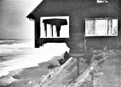
 The house last owned by Harry Roberts, photographed by the 
Corps of Engineers in February 1940, not long before it fell. 
After first hearing about Bayocean eight years ago, I set out to locate the  schoolhouse and six cabins  (counting the Pagodas as two) moved to the mainland before the south end of the spit was blown out by a storm surge in November 1952, a disaster from which the resort town never recovered. I had just located the last of them when Grant McComie called in June 2015 to ask for assistance regarding a program on Bayocean. I then thought it would be interesting to know where the buildings were located on the spit. That led to an obsession with finding every residence ever built on Bayocean, and to learning as much as I could about the homeowners who lost them.  It took me another seven and a half years to achieve that goal. 

If Bayocean Park had been platted in the 1970s, it would have been much easier to locate buildings because property owners would have been required to purchased permits and get an inspector's approval before occupying their homes, resulting in a detailed chronological record readily accessible at the Tillamook County Courthouse. But while the resort town of Bayocean existed, none of that was the case. Homebuilding was a kind of free-for-all. So, I was forced to look for names in newspaper articles, then search deed indexes at the county clerk's office, track ownership back and forth, and go back to look for the other names in newspapers.

Most large metropolitan newspapers like the Oregonian were digitized, so I was able to search them online, but that was true of very  few Tillamook County newspapers. So, I read every original edition or microfilmed copy looking for any mention of Bayocean. Information I was excited to find one day often conflicted with information found elsewhere later. Personal memoirs, government reports, and other archival records helped me parse it all out and fill in gaps. I ran into many dead ends along the way, but most of the remaining pieces of my self-induced Bayocean puzzle fell into place when Denise Vandercouvering, Tillamook County Assessor worked out a way for me to look through historical assessment rolls stored in the courthouse basement after I learned they were organized chronologically by subdivision - just what I needed. 

In Bayocean: Atlantis of Oregon, hopefully published in the next couple of months, I will tell the story of homeowners I was able to find, so readers can get a sense of what they experienced. And I mention at least the first and last owners of each of the fifty-nine houses built and lost on the spit. Some were magnificent, some were shacks or converted garages, but they were all considered home by someone. 

My tally does not include houses on the mainland - one of which was destroyed, others moved, some more than once - because my book is about the spit, which I consider everything north of South Gap (Shell Street and 2nd Avenue) because it was the southern limit of the November 1952 blowout. I counted the Pagodas as two houses because one was built later than the other on the spit, lived in by different individuals, and referred to as such by neighbors. Others might choose criteria that result in a different tally. 

To help myself and readers keep track of the fifty-nine residences, I built a spreadsheet listing each one, their demise, lot numbers, and the last names of each owner. Unfortunately, it was too large to include as an appendix in my book, but you can view and/or download it here. Locating each home will require you to view and/or download the Bayocean Park plat map, which I could not fit on two pages pages of my book and provide sufficient detail. 

For more stories about Bayocean and the challenges of researching it, check out the Index page. To reach a comprehensive narrative, read Bayocean: Atlantis of Oregon

Saturday, February 26, 2022

The Tillamook Indians and Bayocean

Tillamook (Kilamox) Indians lived on the sandspit that would become Bayocean Park for centuries before white men arrived. European fur-trading ships began plying the shores of Oregon at the end of the 17th century, but the first recorded interaction was when Captain Robert Gray sailed the Lady Washington into Tillamook Bay and anchored in Crab Harbor on 
Lucia Wiley’s 1943 WPA painting of Captain Gray's 
interaction with Tillamooks, from Wikimedia Commons. 
August 14, 1788. Third mate Robert Haswell’s log (reprinted in the June 1928 edition of the Oregon Historical Quarterlydetailed the event. After a couple days of peaceful trading at a seasonal camp on Kincheloe Point, Gray’s black servant Markus Lopeus got into a squabble with a warrior over his cutlass that ended with Lopeus’ death. Haswell, who was wounded in the ensuing skirmish between warriors and sailors, dubbed the unnamed bay “Murderers Harbour” as they sailed away. Given the aid, Chief Kilchis gave white settlers beginning in the 1850s, it is ironic that the first known battle between any Oregon Indian tribe and white men occurred on Tillamook Spit. 

A permanent village at the south of the end of the spit, in the meadow where the Bayocean School that is now the Cape Meares Community Center was later built, probably was the home base of the warriors who battled Captain Gray's men. In his 1948 diary, archived at the Tillamook County Pioneer Museum, Bayocean resident Jack Medcalf described longhouse ruins and a large midden there. The location is shown on page 175 of Tillamook Indians of the Oregon Coast, but the landscape in the photo has changed dramatically since then. On page 158, beeswax is reported to have been found there, which would have come from Nehalem Bay Tillamooks who salvaged it from the Spanish Galleon Santo Cristo de Burgos after it wrecked during the winter of 1693–1694 (see “Oregon’s Manila Galleon” by La Follette, Deur, Griffin, and Williams in the Summer 2018 Oregon Historical Quarterly). Diseases brought by sailors decimated the Tillamooks' population to the extent the village on Tillamook Spit had been abandoned by the time white settlers arrived. When  Samuel Snowden surveyed it in 1856, he noted a lone hut at Crab Harbor. 

In 1934, Clara Pearson relayed Tillamook myths to ethnographer Elizabeth Derr Jacobs that were published in Nehalem Tillamook Tales. One offers an explanation for the first people living in the village on the spit moving there from Flower Plot, a meadow along the southern shore of Tillamook Bay. It was a long, gruesome tale about Wild Woman (Xilgo) roasting children for violating a rule against eating while their parents were away. The villagers took revenge by tricking Wild Woman into returning and then roasting her. No one wished to remain there after that.

Clara Pearson also explained how South Wind (Asaiyahal) created Tillamook Spit, but I will use the version Hyas John relayed to Franz Boas because it is shorter. Tim Nidever of Portland State University was kind enough to translate it from Latin before I learned of more recent English versions. The Journal of American Folklore evidently thought the myth was too sexually explicit for the Victorian readers who would read their April-June 1898 edition. At least, that's why I chose not to paraphrase it. 

While traveling the world, he traveled on and came to Tillamook. When indeed he saw a woman across the river, bathing after the completion of her period, he wished to have intercourse with her. And so, his penis, which, on account of its unbelievable length, he carried wrapped around his shoulders, he deliberately cast into the water in order that it might make contact with the woman. By this action, the tip of his penis entered her vagina. By chance, many a water plant was borne downstream against his penis in its shrinking desire so that it was, at length, severed by the constant friction. The tip, conveyed by the river’s current, was transformed into the long and narrow peninsula which today is called Tillamook. As’ai’yahal hung from his shoulders the rest of his coiled penis.

For the scientific explanation of how the sandspit was formed, see Prehistoric Geomorphology of Bayocean Peninsula. For more posts on Tillamook Indians see the Index tab